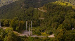
Picture a transmission project crossing mountains and dotted with mining areas. Heavy rainfall is hitting these extreme slopes and loose soil from mining can cause a long—and recurring—list of things to inspect, report, and repair.
That’s exactly where a client of Energy Environmental Group (EEG) found themselves. The utility was working on a transmission project in a rugged area. Keeping up with hundreds of environmental inspections, repairs and cataloging the fixes required a lot of construction crews and environmental managers many hours of work.
Staying environmentally compliant, while keeping construction on schedule, also meant coordinating work and securing permits from federal, state and local government officials. With a less complex job, construction and environment managers could have kept tabs on things with paper, pencil, email and spreadsheets. This was not one of those jobs. In fact, on this mountain-traversing project, inspectors were constantly in the field handwriting the location of each compliance issue, noting what crews should fix. The list of items to repair was always a long one and, sometimes, inspectors would note the same issue in different ways.
Avoiding Violations
As construction crews criss-cross the country to build transmission lines and substations, environmental violations can be a costly schedule-buster. Some construction managers first learn about environmental permits when a regulatory agency fines them for a violation, which can be an incredibly costly introduction to how the process works. Some Clean Water Act violations cost project managers a $1 million per day.
Despite this, managers usually focus on avoiding accidents, but it’s necessary to be vigilant about environmental risks too. A workplace fatality is tragic and would immediately shut down a job for days. By comparison, an environmental compliance issue could halt work for weeks, months or even years. Safety is paramount. But mitigating environmental risks must also rank on a construction manager’s priority list. Environmental violations have a ripple effect on a utility infrastructure project’s schedule. If a regulatory group puts the brakes on a project for environmental concerns, that can impact outage schedules and incur financial penalties for not meeting construction due dates.
There’s a balance to be struck between overprotecting and literally bulldozing ahead. The larger the project, the more complex it is for managers to stay on top of permitting, traversing sensitive habitats and correcting non-compliance issues.
Most construction projects that would disturb an area larger than one acre would require a storm water pollution prevention plan (SWPPP). The plan would spell out erosion control measures, protected species and habitats and require workers to comply with the SWPPP throughout the job including fixing something that goes wrong.
Mountains of Environmental Challenges
On the transmission project, before the data collection was automated, the reporting process began with a stack of field forms transcribed into hardcopy reports and, ultimately, populated a gigantic spreadsheet requiring constant updates to keep up with crews in the field. Despite updates, inspectors and project managers faced problems keeping one version of the spreadsheet, which the construction management team relied on to prioritize and organize the repairs.
Once the construction managers assigned crews to fix a compliance issue, crews struggled to locate where they had to make a repair. For example, if an inspector went into the field and identified a silt fence to mend, the report might state to “fix silt fence between mile marker 1 and 2, adjacent to the big tree on the roadside.“
As a result, it was daunting for the construction crews. For example, there might be hundreds of trees between mile marker 1 and 2 that could be described as a “big tree.’”
As is typical with a project of this size and complexity, there were hundreds of—sometimes up to a thousand—compliance issues popping up. The utility’s construction team and an environmental firm were tracking it by hand. Keeping track of the issues became too much for a manual process, and the utility turned to EEG
Keeping Construction Moving
An interactive web-mapping app was suggested to the utility to solve the problem. The tool does three things. First of all, team members can streamline field data collection and reporting. Secondly, it improves communication among the team by establishing a common platform. And finally, it creates a record of construction and a way to immediately tell whether projects are complying with the environmental permits and regulations.
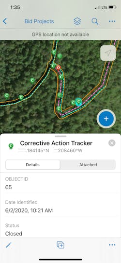
Here’s how the system works: EEG set up a software platform, so inspectors could streamline field data collection using GIS to eliminate errors and reduce reporting time. By electronically capturing data about the terrain, construction, and corrective actions, EEG helped the construction team literally see what had to be done and in what order. As inspectors returned to examine areas of concern, they could take a photo of anything that had been fixed. EEG could then track the corrective action and share it with the construction team.
EEG relies upon a mapping software featuring spatial analytic technologies. The commercial off-the-shelf product allows EEG’s team to customize the software to meet the specific needs of any project. For the mountain-crossing transmission project, a common platform was built for collecting field data.
The intent was getting all team members singing from the same sheet of music. Some team members were using spreadsheets, others used Google Earth, and others were handwriting notes. A common approach solved the problem of field data collection, reporting, and communication.
Expediting Data Collection
EEG desired one platform to speed up data collection and reporting on repairs. When inspectors download the interactive mapping application, they didn’t have to have a cell or internet connection. The application downloaded the aerial imagery and project components and construction activities.
Once downloaded, the app then showed roads under construction, pad sites, structures and sediment and erosion control measures from the SWPPP relative to where the inspector is physically standing. As a team of eight inspectors collected data on their devices during the work week, the updates would automatically synchronize with servers and disperse the reports to EEG, other inspectors, government agencies and the client.
As crews fixed environmental controls in the field, managers and inspectors could see a before-after photo, zoom in, add notes and mark the action closed or open. Managers could also tap the tool to zoom out and easily see areas where there were clusters of corrective issues. The cluster feature helped construction managers organize construction crews to address hotspots.
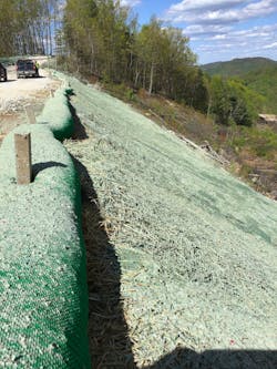
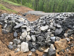
To make inspections consistent and speedy, EEG built drop-down menus in the mapping application, so inspectors and crews would see the same name for a construction activity, location, or corrective measure (e.g., fix a filter sock, rebuild a rock-check dam, stabilize matting, etc.). Users could prioritize the action with a drop-down menu, so construction managers knew they had to repair something immediately, within a few days, or over a longer period. A filtering tool gave the construction team data by repair type, priority, repairs made during a specific date range and other classifications. If the construction crews had questions, they could contact inspectors because their name, status, and date and time of inspection were on the report. At the height of the project, the team was accurately tracking more than 1,000 environmental items.
EEG shared a version of the mapping application with regulatory agencies, which appreciated the nearly real-time updates. EEG could upload a photo of a corrective action and call the state inspector and its client to get immediate feedback.
EEG’s client, subcontractors and regulators were hesitant about the analytics and mapping application at first. But the project was pursued to fully disclose issues and quickly identify solutions to ensure managers deployed the right resources. EEG has used the analytics and mapping tool on projects in other parts of the United States. But the terrain, weather, and sheer number of corrective actions for the mountain-transmission project had EEG’s team pushing the application to its maximum potential.
Kevin Seegmiller ([email protected]) is environmental director for Mesa, Arizona-based Energy Environmental Group, which handles all environmental aspects of developing and constructing projects for EHV infrastructure, mining, oil & gas and other industries. Kevin earned a bachelor’s degree in environmental studies and economics and a master’s degree in bioregional planning from Utah State University.
