Damage Prediction Model Improves Storm Response
In 2011, the Connecticut Light and Power Co. (CL&P), a Northeast Utilities company, was ravaged by the two largest storms in the company’s nearly 100-year history. Tropical Storm Irene in August and the October snowstorm occurred less than 10 weeks apart and caused a combined 1.5 million customer outages in Connecticut. The incidents highlighted the need for an improved method of linking pre-storm weather forecasts to operational preparedness trigger points, such as securing and deploying resources. More importantly, the process would need to be robust yet flexible enough to also incorporate Northeast Utilities’ electric operations in Massachusetts and New Hampshire.
In March 2012, Northeast Utilities entered into a partnership with the University of Connecticut (UConn) School of Engineering to research and develop a Damage Prediction Model that would provide quantitative estimates of the damage to the overhead electric distribution network, both in scope and dispersion. The intent of the project was to link National Weather Service weather forecasts, through a high-resolution numerical weather prediction model of the northeast United States, with operational trigger points involving the planning, operations, logistics and communications functions within the company’s Emergency Response Organization. Another long-term objective included using the predictive model to assess the real-world results of infrastructure hardening and capital investment reliability programs.
Utilities across the U.S. use raw meteorological data and local forecaster assessments in an attempt to predict infrastructure damage and, ultimately, customer impact. These predictions, commonly calculated based on a wealth of operational and historic storm knowledge, become the basis for the entire planning process. Unfortunately, historic system performance to weather events does not cleanly foretell future incident performance. Additionally, strong regulatory scrutiny in Connecticut following severe storms has fueled the need for a more scientific, replicable and defensible approach.
Following the historic storm season of 2011, CL&P recognized the need to reassess the process of evaluating the potential impact of developing threats. The process began with assessing more than 20 years of historical storm data.
Data, Data, Data
The CL&P outage management system and associated databases contained historic outage data for significant storms all the way back to Hurricane Gloria in 1985. Information pertaining to customer outages, device impact and general cause was recorded and available in one form or another. Using this information, a project team consisting of CL&P personnel and UConn staff and graduate students began developing a storm database. The database included three distinct categories: weather, infrastructure/asset data, and geographic data.
Using the storm dates to establish a timeline, the team began researching meteorological and geographical data from sources such as the National Weather Service’s National Climatic Data Center and UConn’s Center for Land Use Education and Research. Numerous variables were identified as potentially significant contributors to actual infrastructure damage. Additionally, some variables, such as leaf coverage, were not available or recorded consistently and therefore identified as data gaps.
Building an Analytical Model
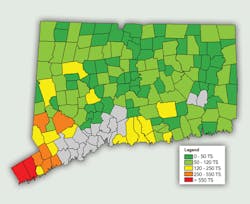
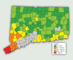
The intent of the model development was to derive a solution for both the total number of damage locations, referred to as trouble spots, and also the dispersion of damage locations across the state of Connecticut. This was accomplished by associating the model variables to municipal boundaries. This required a significant amount of work as most asset data and damage data was recorded using circuit designation. This was challenging as many municipalities contained numerous circuits while several circuits served multiple municipalities.
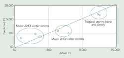
Using approximately 80 historical weather events, a model was developed that first uses a logistic regression to assess the likelihood a geographic bounded area will experience at least one weather-related trouble location.
Next, all locations within that subset are reanalyzed, based on the total number of electrical circuit isolating devices, to determine the total number of trouble spots within a city or town boundary using a regression model. Trouble spots are associated with primary isolating devices and individual customer services to ensure the total trouble count will not exceed the possible number of devices per geographic area. For the purpose of the model results and planning assumptions, a trouble spot is associated with a unique location that requires the dispatch of a repair crew. Model results are also influenced by the type of weather system that is forecasted to impact the system: convective (primarily occurring in the summer), synoptic (winter and fall season) and tropical storms.
Model Outputs and Operational Decisions
Globally, the total trouble spot count is a factor in determining extent and distribution of potential system damage. It provides a quantitative data point into a process that has historically relied on a more qualitative analysis. All restoration-related data can, at some point, be linked to the total amount of damage incurred and therefore provides a logical initiation point for restoration planning. Estimations of total resource needs, logistical support requirements and event-restoration duration all rely on an early and accurate damage estimate.
The Damage Prediction Model outputs, when combined with additional restoration estimates such as crew productivity (number of trouble spots resolved per operating period) and resource arrival times, provide the incident planning team greater situational awareness. Additionally, the trouble spot distribution by town allows for pre-impact allocation of resources to areas that are forecasted to sustain the greatest damage. This level of planning allows for the coordination and alignment of not only field forces, but also the logistical resources, both personnel and materials. The planning and logistics functions within the Incident Command System structure assess the predicted trouble dispersion in determining the need and locations for staging sites, preplaced materials and telecommunications assets for satellite operating locations.
The incident planning team also can evaluate availability and travel requirements for additional support resources. The decision to secure additional resources outside the immediate region can be tempered with estimated restoration duration and daily work projections. Additionally, operational decisions such as a de-energization of projected highly impacted areas or closure of threatened facilities may be supported by the calculated results. Unified messaging with state and local officials concerning event preparations also would be reinforced.
Ongoing Model Refinement
Ongoing Damage Prediction Model refinements include the incorporation of “no or low impact” events (weather forecasts that resulted in little or no damage to the system). This additional data allows the model to incorporate recent modifications or upgrades to the system due to past events and capital investments. Additionally, the opportunity exists to cluster geographic areas with similar attributes, such as elevation and tree canopy height, based on their response to known weather conditions. This clustering allows calibration of the Damage Prediction Model using ensemble weather forecasts that more accurately predict the weather variables that have the greatest impact on that area.
Additionally, analysis into weather forecast accuracy has identified those weather attributes that are consistently more precise in a given weather model. Outputs from the Global Forecasting System and the European Center for Medium-range Weather Forecasting forecast models are widely accepted public models; however, they do not always appropriately forecast those variables that are more critical to an electric system damage estimate. UConn continues to assess various weather models in order to develop an ensemble that will drive higher precision and accuracy in the Damage Prediction Model.
From Damage Prediction to Resiliency Planning
While the prediction of ensuing storm damage has been the catalyst for the model development, it has proven to be but the “tip of the iceberg” in terms of applications. Ongoing model refinements, including Logic Tree, Bootstrap Forest and Bayesian regression modeling, have revealed additional benefits to increased data collection and analysis. The inclusion of data associated with CL&P’s Enhanced Tree Trimming program, where ground-to-sky vegetation management techniques are applied, allows for the analysis of how such improvements might have influenced performance in past storms. Additionally, performance factors can be incorporated into the existing model to analyze how future improvements, such as asset replacement or storm hardening, may increase grid resiliency. This type of analysis not only allows company planners to assess the type and location of system improvements, it also may be used to justify additional spending for future system-resiliency projects where the value could now be measured.
A Promise for Future Resiliency
The UConn Damage Prediction Model allows CL&P to make better decisions around committing resources to an incident based on the forecast probability of occurrence.
Historically, utilities have relied on experience and historical knowledge of past incidents to assess the threat of a pending incident as well as to determine the need and allocation of critical resources. In light of increased customer expectations and regulatory oversight, a more reasoned approach is needed to determine when and how many additional resources may be required and, more importantly, how the costs associated with those resources would be justified, especially if the incident failed to develop.
The employment of a scientifically developed damage modeling not only pays dividends in terms of immediate storm preparedness, but also shows promise in providing discrete analysis for future system-resiliency initiatives.
The partnership between CL&P and the University of Connecticut has allowed innovators and educators on both sides to push the envelope of traditional utility thinking and has at least broached the possibility that there exists a true “crystal ball” for electric utility storm-damage predictions.
Dean Desautels ([email protected]) is the manager of emergency management at Connecticut Light and Power and the Northeast Utility lead for the University of Connecticut Damage Prediction Model project. He is a 14-year veteran of the electric utility industry with experience in distribution engineering, substation operations and maintenance, transmission asset management and emergency preparedness. During large-scale restoration events, he serves as CL&P’s deputy incident commander, responsible for planning, operations and logistics functions.
Companies mentioned:
Connecticut Light & Power | www.cl-p.com
National Weather Service | www.weather.gov
Northeast Utilities | www.nu.com


