Sustainability Requires Forward Thinking: Leveraging GIS Technology
With tighter regulations, today’s vegetation managers are under a lot of pressure to control a wide variety of site conditions that could pose an imminent threat to system reliability. Utilities must also implement an annual plan for vegetation management, requiring the ability to anticipate growth and changing environmental conditions.
Develop a Predictive Approach
The key to compliance lies in developing a vegetation management program that is both predictive and sustainable; an activity that requires the ability to model, predict and mitigate vegetation threats within rights-of-way (ROW) before they occur.
Many utilities today are looking to Geographic Information System (GIS) technology to selectively manage the growth of potentially hazardous vegetation while promoting the growth of compatible species. It’s a system comprised of hardware, software and data that makes it possible to intersect, analyze and visualize vast amounts of information on interactive maps. Leveraging GIS makes it possible to integrate a spatial vegetation inventory with computerized growth and treatment response modelling for a predictive and future-oriented approach.
Take an Accurate Snapshot of the Situation
Proactively mitigating threats to power lines requires access to the right data at the right time. Investigations into the cause of the 2003 blackout revealed a need for data that is more accurate, gathered with better tools, to correctly gauge the distance between vegetation and conductors.
Thus, an essential first step to developing a sound, compliant vegetation management program is to build an accurate and comprehensive inventory of vegetation-related data. This can be accomplished through either ground level, aerial interpretation or perhaps LiDAR to capture attribute data.
GIS-generated spatial models and inventories can take it from there providing the level of detail that utilities need to accurately visualize what is happening along ROWs in real time, often without the need to rely on LiDAR data.
Utilities can gain many advantages by collecting data on a discrete unit level, the first advantage of which is to understand where project work is not required, eliminating one level of concern. While treatment work is unit-based, management plans can account for vegetative diversity and terrain operability within the corridor.
GPS points and a GIS-generated map view make it possible to more thoroughly capture vegetative similarities and create boundaries where they are best suited — an activity that is critical to accurately determining current and future vegetation management treatments and relative costs. The end result is an enhanced ability to be in the right place at the right time with the right treatment to align with management thresholds or preempt any issues.
Even more benefits can be gained by shifting away from line management cycles. These cycles involve scheduling work to be completed on a fixed schedule, according to what is most often an annual timeline, which may, in fact, be too early or, worst case, not capture critical areas requiring a higher level of tracking.
North American Electric Reliability Corp. (NERC) standard FAC-003-1 requires vegetation management standards to be flexible enough to adjust for changing conditions. The inspection schedule shall be based on the anticipated growth of vegetation and any other environmental or operational factors that could impact the relationship of vegetation to the transmission lines. Using GIS data, it is possible for utilities to take a more informed and targeted approach to vegetation management, because, at a glance, they are able to spatially locate areas reaching a threshold for management and dispatch crews based on actual need rather than a static time cycle.
Map Out Sustainability
It’s generally accepted that the single largest cause of electric power outages arises from trees or portions of trees that grow or fall into overhead power lines. Thus, measuring the sustainability of ROWs is a key component of any successful vegetation management program. For example, at Nova Scotia Power Inc. (NSPI), accurately gauging the sustainability of ROWs involves grouping management units according to the absence of trees. Three categories of sustainability are used: inherent, natural and managed.
Inherently sustainable units are those that lack any vegetation such as water or pavement.
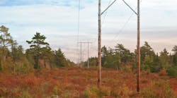
Naturally sustainable rights-of-way refer to those comprised primarily of compatible vegetation. While obvious with inherent sustainability, naturally sustainable areas do not require frequent management and as such, are considered extremely cost-effective. They also provide stable, open-growth habitat for small mammals and birds.
Managed sustainability is used to categorize management units that have the potential to be converted to naturally sustainable areas through integrated vegetation management techniques (IVM). A multi-year plan is designed to carry out this conversion. Developing these types of classifications enables utilities to estimate the percentage of rights-of-way that requires intensive management on a more frequent basis, to ensure safety and reliability.
Through a GIS-generated map view, a utility can get a snapshot of its current situation and measure the overall sustainability of its ROWs. It can also identify areas requiring selective management or opportunities to plant low-growing species that eliminate the need for frequent maintenance. These activities can be monitored, tracked, studied and refined to continuously increase overall sustainability. Achieving sustainability along ROWs not only benefits the surrounding environment, it is also integral to driving down long-term costs.
Model Reliability
When NERC compliance became mandatory in 2005, two main objectives were at play:
- Ensure that utility companies develop vegetation management programs that meet key performance criteria
- Eliminate outages caused by vegetation within or adjacent to the ROW
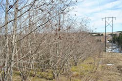
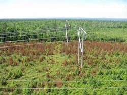
To achieve these objectives, utilities should consider developing GIS-based treatment response models that enable staff to predict future vegetation treatment needs and maintenance schedules. These models are similar to those used in the forestry industry and provide a mechanism to estimate height growth for each forestry stand type. For example, after an intolerant hardwood management unit is ground cut, it is possible to model and predict when the next phase of IVM is required.
The prediction is made by combining attribute data representing rights-of-way including vegetation species composition, height and density, site class and terrain classification. The information can then be plotted on growth curves making it possible to predict how the site will respond and how fast new vegetation might grow and how existing vegetation will respond to different treatment types.
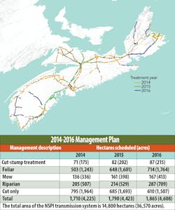
At electric utilities, like most companies, business drivers change. One year, budget might be a major constraint, whereas the next year, government policy concerns might be the primary driver behind decision-making. For this reason, at NSPI, an optimization model was created that leverages data from the growth and response model, factors in other considerations such as yearly financial targets or reliability standards, and designs optimal programs based on this information. This functionality allows the utility to strategically plan confidently, up to five years into the future, and create a system that supports the lowest possible long-term costs, while ensuring the system meets all reliability requirements.
Bringing it all into Focus
Standardizing on a single GIS platform makes it possible for utilities to complete a number of vegetation management-related tasks from a central system. This includes creating detailed work plans, generating customer notifications and compiling NERC-compliant reports, all drawing from the latest available data. It also makes it easier to extract data for comprehensive reporting required by FAC-003-1 including outage reports for the Regional Reliability Organization that must be broken out into specific categories. Drawing upon this system, utilities can regularly track performance, compare crew productivity and analyze unit costs.
While it is often thought that stricter compliance requirements translate into greater costs for utilities, this doesn’t have to be the case. Apart from providing safe and reliable electric service, a proper vegetation management program can help utility companies operate at the lowest possible cost, through enhanced efficiencies that mitigate the occurrence of unforeseen expenditures.
Additionally, GIS provides powerful analysis capabilities to support an informed approach to budgeting: by combining unit data, treatment type and vegetation density, costs associated with integrated vegetation management activities can be automatically generated. The results can then be used to predict expenditures for proposed work plans and to lock down a multi-year outlook that makes it possible to secure the best possible cost estimates from contractors.
Looking to Tomorrow
Though it is impossible to predict the foreseeable future with complete accuracy, some things are certain – NERC standards will continue to expand, compliance monitoring processes will further tighten and unanticipated environmental restriction will likely unfold. More than ever, utilities need to be one step ahead of the game and invest in the technology necessary to build a future-proof vegetation management program. The good news is that through a combination of sound planning and the right tools, it is possible to reduce costs, ensure compliance and enhance overall network reliability.
About the Author:
Robert F. Young, BScF, RPF, has worked in the forestry sector for over 25 years, primarily focused on utility vegetation management at Nova Scotia Power Inc.
