More than 25% of the service territory for Southern California Edison (SCE) is located in high-fire risk areas. To protect the communities it serves and its electric system, the utility is fortifying its system, ramping up its inspection efforts, bolstering situational awareness and focusing on a comprehensive vegetation management plan as well as other operational practices.
Like other California utilities, SCE submitted and received approval of its annual Wildfire Mitigation Plan from the California Public Utilities Commission (CPUC), but the company’s proactive measures have been a longstanding practice. For example, the utility has focused on robust design and construction standards, vegetation management activities and operational activities.
Putting the Plan into Practice
The new 2020 Wildfire Mitigation Plan takes a broad approach that includes enhanced inspections on all of the company’s overhead power lines in high fire risk areas in the immediate term to identify and remediate potential issues outside of standard inspection cycles. The plan also includes specific metrics that provide transparency to the public and other stakeholders and will enable the CPUC to evaluate SCE’s performance.
The company has already completed its inspection of transmission and distribution lines in high-fire-risk areas. SCE has also already deployed 500 miles of power lines with covered conductor and plans to install 700 more miles by the end of 2020. The utility has also installed fast-acting, current limiting fuses that will also help boost reliability by segmenting circuits to isolate problems at more than 10,000 locations.
To date, 482 weather stations have been installed, with plans to deploy up to 850 by the end of 2020. Advanced weather modeling software uses information from these devices to help predict extreme weather conditions down to less than two miles. Information from the weather stations and camera feeds is publicly available.
SCE has installed 161 high-definition cameras that visually cover nearly all of SCE’s high fire risk areas. “The cameras showed us the likely time the Holy Fire originated in Orange County, California. We used them to follow the fire spread,” said Brian Norton, division chief of Orange County Fire Authority. “During a flare-up that occurred near Santiago Peak, the initial report was validated by turning the cameras to view the entire mountaintop.”
The company is also using fire simulation modeling that can determine the likelihood of a large fire starting in fire-prone areas, as well as advanced weather modeling software that can predict extreme weather conditions down to less than two miles.
Focusing on Vegetation Management
Vegetation management is a key aspect of the company’s approach to wildfire mitigation. Mike Jones, a senior specialist in SCE’s Vegetation Management group, vividly remembers patrolling the Santa Monica Mountains with the Los Angeles County Fire Department during the inaugural vegetation inspection event known as Operation Santa Ana in the spring of 1999.
Operation Santa Ana was named after Southern California’s Santa Ana winds that typically occur from September to May. The hurricane force winds, combined with low relative humidity and hot temperatures, create extreme weather conditions. The goal was to locate tree branches encroaching on power lines and find overgrown vegetation on utility poles in fire-prone communities.
Two decades later, the goal remains the same, although Operation Santa Ana has expanded from three counties to cover SCE’s entire 50,000-square-mile service area. “It’s been a huge learning experience since we started these inspections two decades ago,” Jones said. “Looking back on this partnership with fire agencies, I take pride in the fact that this proactive approach to public safety and fire prevention was piloted by Southern California Edison and adopted by other utilities in California.”
The visual inspections during Operation Santa Ana are conducted in person and while driving through neighborhoods. Some SCE arborists find, on average, up to seven trees or more during a 10-hour shift that might need trimming. If that’s the case, a contractor crew is dispatched to cut the branches or vegetation away from the power lines or poles immediately.
LA County Fire Department Assistant Chief J. Lopez said fire vehicles and forestry division officers are present at every inspection location, so property owners understand that this work is being conducted to protect homes.
“The collaboration is critical,” Lopez said. “Power lines and branches don’t do well together during a high-wind situation, so prevention is the main component.”
Determining Wildfire Risk
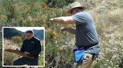
The company is also using fire simulation modeling that can determine the likelihood of a large fire starting in fire-prone areas. This technology incorporates data from SCE’s new vegetation sampling program. As Biologist Matthew Malle and his team search for new growth on branches and other vegetation in the hills above Santa Clarita in Los Angeles County, he knows how critical this process is when figuring out the wildfire risk in the area.
“Live fuel moisture sampling is the main factor in determining how brush will burn during a wildfire,” Malle said. “As determined by our work with the L.A. County Fire Department, vegetation with moisture content approaching 60% and lower is considered an increased fire risk.
Malle works for AECOM, a company that recently helped with a live fuel moisture sampling pilot program with SCE and the LA County Fire Department.
“The pilot program ran from June to August and was highly effective,” said Tom Rolinski, SCE’s fire scientist who oversees the utility’s new, in-house live fuel moisture sampling program. “We’ve always relied on live fuel moisture sampling data from fire agencies, but there are gaps in some of the data. By bringing the program in-house, we can help fill in those gaps.”
Some high fire risk locations where vegetation will now be collected include: Idyllwild, Banning Pass, Hemet and L.A. County along the 14 Freeway.
Analyzing Moisture Levels
The process begins with the collection of up to 50 grams of vegetation. As soon as each plant is clipped, it’s placed in a container and sealed since it starts losing moisture immediately.
“We do not collect samples when the chaparral foliage is wet from rain, dew or fog. Errors can occur if plants are collected during wet weather and we want the most accurate data possible,” Malle explained.
The vegetation is then taken back to a lab to undergo moisture level testing. All the plant samples are weighed before and after being placed in an oven at about 200 degrees for up to 20 hours to determine the moisture amount.
The data collected through this process will improve the accuracy of SCE’s live fuel moisture computer modeling which is being used to predict wildfires in high fire risk areas. The data is already being shared with fire agencies and the public through the National Fuel Moisture Database.
“As we continue to fill those data gaps, the information will also help refine SCE’s decision-making process when it comes to potentially turning the power off during extreme weather conditions,” Rolinski said. “That’s something the utility takes very seriously and never wants to do unless it’s absolutely necessary.”


