According to Korea Forest Service, about 70% of the land is mountainous in Korea, where 567 cases of wildfire occurred on average every year for the last 10 years. Annually 4,004 hectares of land is affected by wildfire in Korea, inflicting damage equivalent to about 227 billion Korean Won (about USD164 million).
It is critical to respond to a wildfire by pinpointing where it happens as early as possible because it spreads quickly. KEPCO found that introducing a monitoring system in mountainous areas is expensive as mounting structures, power lines and communication networks need to be installed additionally in a worker-unfriendly terrain. Even with investments such as CCTV cameras, utility workers frequently misidentified fog, tricks of the light, etc. as wildfire or smoke. To sharpen its wildfire detection capabilities, KEPCO developed a wildfire early response system that employs artificial intelligence (AI) and uses the existing power transmission infrastructure.
Building with Existing Infrastructure
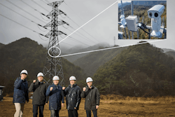
KEPCO used its existing wireless telecommunication cell sites and transmission towers in the mountains, where it is difficult to build the necessary infrastructure. Workers installed high-performance cameras in the cell sites and on the transmission line towers. They can take optical and thermal images and send them to the remote servers for further analysis.
The images acquired at the wireless telecommunication by the cameras are sent to both on-site image analysis module and remote servers and analyzed by the latest artificial intelligence technologies (e.g., the ensemble technique) especially at the remote servers, which meaningfully enhance the accuracy of AI analysis. The results of analysis are shared with Korea Forest Service, National Fire Agency and other institutions for a rapid response.
The cameras on transmission towers are powered by batteries that are charged by solar photovoltaic panels, which can last up to 48 hours even if the PV panels cannot generate power. The image analysis module communicates with the server through the LTE telecommunication network, and some of them are connected to the optical ground wires (OPGW) installed on the transmission towers.
Since KEPCO used its own infrastructure (i.e., no new installation of lines, poles, etc. in the mountainous areas was required), KEPCO was able to establish its system at almost half the price that would have been required to build a similar system from top to bottom.
The wildfire early response system prevents large scale blackouts by preventing damage to not only people and properties, but by protecting the transmission infrastructure. It reduces the risk of a large-scale power outage in the power system.
Where There’s Smoke
KEPCO applied numerous technologies and ideas to wildfire early response system, which enabled the system to detect wildfires at or above 99% accuracy. Some of them include:
The cameras that can take both optical and thermal images high above the ground, which can differentiate the naturally formed fog and clouds from actual wildfire smoke.
Cameras are mounted on actuators that move in eight preset degrees of angles at preset time interval to cover 360 degrees.
When an image suspected to be from a wildfire is captured, the system automatically analyzes the image further. If a sign of wildfire appears from a distance, the system can zoom in up to 50 times to enhance the accuracy of its analysis.
Environmental sensors are installed together with the cameras, to read the surrounding temperature, humidity, wind speed and direction, carbon monoxide density, etc. on a real-time basis. Together with the data received from other institutions, such as Korea Meteorological Administration, etc., the system analyzes the input comprehensively.
The system determines whether the subject image taken from a location portrays the fog or the smoke using the data acquired by the above environmental sensors and the output from KEPCO’s own fog forecasting model. To enhance the accuracy of such forecasts, the system also refers to the climatological data gathered by thermal imaging camera, before finally determining whether the image portrays a wildfire or a fog. KEPCO received the 10-year historical data collected by Korea Meteorological Administration, which became the basis of its fogging possibility model. With the added help of the deep learning technique, KEPCO’s fogging possibility model is now able to predict the occurrence accurately.
- The areas where a wildfire cannot possibly occur (such as the sky) had been labeled as “exclusion area” to lower the possibility of false alarm — when a body of smoke or a spark is detected in such areas, the system checks this against additional data it has, such as thermal imaging, to determine whether it is actually a wildfire. The analysis occurs in multiple locations — in the
mountains where the image analysis modules are located together with the cameras, and in the remote servers. The sequence-based ensemble wildfire detection model is applied to the servers, which carries out a complex diagnosis to minimize false positives. - The image analysis modules have a wildfire detection model, and the remote servers have the ensemble model that consists of seven wildfire detection sub-models.
- The image analysis modules send the data to the remote servers when they detect wildfires. Subsequently, the ensemble model analyzes the data and hard votes to finally determine whether wildfires have actually occurred. A hard vote is a machine learning term meaning that several variables were used to make a prediction by majority “vote.” This is as opposed to a soft vote, where each prediction has a probability analysis done and confidence level is considered.
- KEPCO taught the wildfire detection models using 840,000 images of fire and smoke and continues to improve the algorithm to enhance the accuracy further. Based on the above efforts, KEPCO was able to enhance the accuracy to 99% or above and is committed to continue to have the system machine-learn the images of wildfire to enhance the accuracy further.
Remote Control
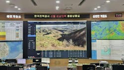
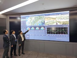
The control system for the system is located in KEPCO’s headquarters to efficiently control the CCTV cameras scattered in the country. The operator can easily identify the locations of cameras from the national map. When the system determines that a wildfire broke out, it sends an alarm to the operator and the screen displays the images fed by the applicable camera to attract the attention of the operator.
The operator can browse both optical and thermal images from the cameras on real-time basis, as well as the readings from the environment sensors. The system makes its determination considering the results of its analysis and the information fed (also on real-time basis) from Korea Meteorological Administration.
The image analysis modules can be remotely monitored – the operator can check the conditions of camera batteries, telecommunication signals and other hardware, and remotely reset certain equipment when they malfunction.
KEPCO’s wildfire early response system, based on its performance, won the President’s Award in 2023 at the Active Administration Best Practice Contest hosted by the Korean government.
Currently, KEPCO has installed the system in 25 transmission towers and wireless telecommunication cell sites in three out of nine provinces in Korea for demonstration purposes. KEPCO intends to work closely with the relevant government authorities and local governments to broaden the coverage of its system nationwide by installing the system in some 20,000 transmission towers and wireless telecommunication cell sites.
Based on the performance of the system, KEPCO is now looking to share its experience and transfer the system to other countries suffering from wildfires as a solution less expensive and more accurate to prevent wildfires. KEPCO is eager to talk to and work with its counterpart including utilities to minimize the impact of wildfires and keep our forests and planet green and safe.
About the Author
Kyungsoo Park
Kyungsoo Park is Vice President of ICT Planning Department at Korea Electric Power Corporation (KEPCO). Park is former Head of ICT Planning Team, former Head of Infrastructure Administration Center, and former Director General of Eumseong at KEPCO.


