LA Wildfires: Key Risk Indicators Were Detectable Using Satellites and AI Well Before Ignition
A study from AiDASH reveals that LA's recent wildfires were not inevitable. The risk factors leading up to ignition were detectable weeks in advance through satellite-driven vegetation stress and ignition analysis.
Using six months of satellite data from the affected areas—Palisades, Eaton, and Hurst—and analysis using proprietary Al models, the study shows that key risk indicators crossed critical thresholds well before ignition, underscoring the urgent need for data-driven wildfire prevention and mitigation strategies.
These fires were fueled by a combination of prolonged drought, critically dry vegetation, elevated temperatures, and extreme weather conditions. They serve as stark reminders of the escalating wildfire risks posed by climate change and environmental degradation.
Analysis of the factors behind these fires provides key insights into how vegetation dryness, fuel conditions, and climatic trends converge to create conditions ripe for ignition and rapid spread.
It shows that proactive, targeted vegetation management, such as fire breaks, could have mitigated the impact of the LA wildfires, and it reveals a course of action that the utility industry can take now to prevent more of the same.
Rising key risk indicators
By tracking key risk indicators, we can see potential wildfires coming and can take preventive action.
The Normalized Difference Vegetation Index (NDVI) is a key metric used to measure the health and density of vegetation by analyzing satellite imagery. NDVI provides insight into vegetation health, biomass, and dryness, making it a vital indicator for wildfire risk. Through the second half of 2024, the percentage of healthy, dense vegetation in all three areas plunged, leaving large and increasing amounts of potentially dry, dead, or dying vegetation.
The Evaporative Demand Drought Index (EDDI) revealed intensifying drought conditions across the area throughout 2024. The drought conditions peaked in December 2024, and fuel moisture levels dropped below the critical threshold of 13.5%, which increased susceptibility to ignition.
Rising land surface temperatures (LST) across a hot summer in the region was a compounding factor that contributed to further vegetation desiccation.
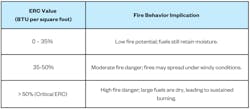
Energy Release Component (ERC) is a measure of fuel flammability. The ERC consistently exceeded the critical threshold of 50% in all three regions towards the end of 2024, leading to high fire danger—large, dry fuels that lead to sustained burning.
Normalized Difference Vegetation Index (NDVI)
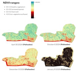
An NDVI spot value refers to the specific NDVI measurement for a particular location (or "spot").
NDVI spot values for Palisades from April 30, 2024 to Jan. 15, 2025. Source: Airbus Imagery, 3km x 3km resolution.
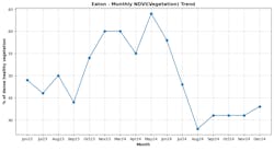
In the Palisades, NDVI values dropped to 0.3 by Oct. 8, 2024, indicating critical vegetation stress. In Hurst, NDVI values fell to 0.28 by Nov. 17, 2024, reflecting severe dryness and a continuous fuel load. This trend was mirrored in Eaton, where NDVI declined steadily, reaching 0.35 by Sept. 2, 2024, and further dropping to 0.3 by Dec. 15, 2024.
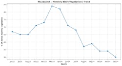
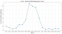
The charts below show NDVI vegetation health in each of the three areas. The percentage of each area with dense and healthy vegetation declined significantly through the latter half of 2024. The drastic drop suggests a notable transformation in the landscape's vegetation, leaving large amounts of potentially dry, dead, or dying vegetation.
Monthly NDVI values showing what percentage of each area maintained dense and healthy vegetation from January 2023 through December 2024. Source: USGS Landsat
Evaporative Demand Drought Index (EDDI) and land surface temperatures (LST)
This vegetation dryness was exacerbated by minimal precipitation and prolonged drought conditions. The Evaporative Demand Drought Index (EDDI) revealed intensifying drought conditions across Los Angeles throughout 2024.
By late fall, all three wildfire zones experienced EDDI values exceeding 2.0, signaling extreme drought stress. The drought peaked in December 2024, just weeks before the fires, with the Hurst area showing the most severe conditions as EDDI values surpassed 2.5.
Further exacerbating the vegetation-driven risk was the lack of precipitation in the months leading up to the fires. Persistent dry conditions in all three regions reduced fuel moisture levels below critical thresholds of 13.5%, increasing the susceptibility of the landscape to ignition.
Compounding this, rising land surface temperatures (LST) contributed to further vegetation desiccation. In the Palisades, LST increased from an average of 77.7°F in 2023 to 84.5°F in 2024 during the summer months. Similarly, Eaton and Hurst saw LST averages rise from 80.2°F to 90.3°F and 88.7°F to 97.7°F, respectively, during the same period.
Energy Release Component (ERC)
Another key metric referenced in wildfire risk assessment is the Energy Release Component (ERC), a measure of fuel flammability. Higher ERC values (>50%) indicate drier fuels and increased fire danger.
The ERC consistently exceeded the critical threshold of 50% in all three regions towards the end of 2024, indicating extreme potential for heat release. Elevated ERC values in late summer and fall highlighted the cumulative drying of vegetation and the increased likelihood of ignition and fire spread.
Monthly ERC values from January 2023 through December 2024 showing the rapid increase in drier fuels and increased fire danger throughout 2024. Source: GRIDMET
Proactive and reactive vegetation management
Vegetation acted as the primary fuel for ignition and fire spread in all three regions AiDASH studied. Had utilities been equipped with the data about rising risk indicators, they could have taken proactive vegetation management measures before the wildfires broke out, and they could have taken reactive measures to prevent spread, too.
Proactive vegetation management focuses on systematic fuel load reduction through thinning, prescribed burns, and mechanical clearing. The implementation of strategic fuel breaks has proven effective, particularly where broad roads combine with fire-retardant species and brushed green patches to create defensive barriers. In Wildland-Urban Interface (WUI) areas, the creation of defensible spaces—maintaining ember-resistant zones around structures and thinning vegetation within 30 to 100 feet of buildings—has significantly enhanced community protection.
The reactive approach leverages real-time wildfire ignition and spread risk assessment models to guide emergency response and mitigation efforts during active fires. These models integrate weather conditions, fuel loads, and topography to identify high-risk zones and determine strategic responses, including emergency fuel break creation and backburning operations.
The key lesson from these fires is that vegetation management provides a crucial lever for wildfire risk reduction, even when environmental conditions may be beyond immediate control—and technology offers a powerful means of acquiring critical data and actionable analysis.
Learning from fire breaks: Three case studies
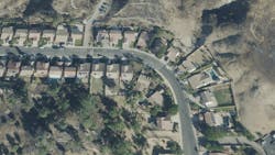
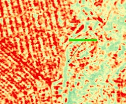
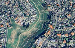
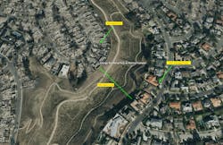
Ironically, the damage the LA wildfires caused demonstrates how and where vegetation management can be effective in mitigation efforts. In AiDASH’s analysis of satellite imagery from both before and after the wildfires, we examined three sample cases where natural and managed fire breaks halted the fire progression.
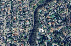
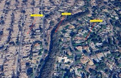
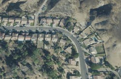
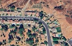
Case study 1: High-moisture vegetation as a natural barrier. A line of tall trees with high moisture content protected one neighborhood from the encroaching blaze that decimated an adjacent neighborhood.
Not only did the less-dry vegetation feed less fuel to the fire, the tall trees helped prevent airborne embers from spreading and causing further ignition.
The effectiveness of this barrier suggests that incorporating fire-resistant species into vegetation management plans could create natural fire breaks.
Case study 2: Strategic distance management. In another case, a wide clearing reduced fire spread between two neighborhoods. Where clearings exceeded 100 feet, fire spread was more contained. Notably, this distance is affected by wind; when winds are stronger, clearings need to be wider to offer the same protection.
This finding emphasizes the importance of dynamic vegetation management that accounts for local weather patterns and wind conditions.
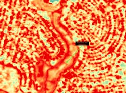
Case study 3: Urban interface protection. In Wildland-Urban Interface (WUl) zones, where residences meet undeveloped land, low fuel density helps protect populated areas from wildfires.
These real-world examples from the LA wildfires provide clear evidence that strategic fire breaks can effectively mitigate wildfire risks. This understanding can inform more effective vegetation management strategies that use fire breaks. These strategies include:
- Strategic placement of moisture-rich, fire-resistant vegetation to create natural barriers.
- Implementation of sufficient clearing widths based on wind condition analysis.
- Careful fuel load management in Wildland-Urban Interface (WUl) zones.
These insights reinforce the importance of data-driven vegetation management in wildfire prevention and highlight how satellite monitoring can help identify and maintain effective fire breaks.
Necessary technological advances
The effectiveness of vegetation management strategies has historically been constrained by limitations in monitoring capabilities. Traditional approaches relied on infrequently updated, low-resolution imagery that failed to capture rapid changes in vegetation conditions. Modern wildfire prevention demands higher-resolution imagery and more frequent monitoring to detect early warning signs of fire risk.
A path forward
Large-scale disasters can make us feel powerless. But there is plenty the utility industry can do to help prevent wildfires from happening in the first place—and mitigate their impact when they do happen.
We can track key risk indicators like the health and density of vegetation in a given area, as well as rising temperatures. As risk indicators rise, we can use strategic, proactive vegetation management to reduce potential fuel load in our RoW. During a wildfire event, we can create fire breaks and perform emergency vegetation trimming in high-risk areas.
Our research shows that these strategies can be effective in reducing the chance of wildfire ignition and spread.
The technology to do all of this is advanced, but it already exists: high-resolution satellite monitoring combined with AI to track, analyze, and produce actionable data.
The integration of high-resolution satellite monitoring with proactive vegetation management strategies offers a powerful approach to identifying and mitigating fire risks before they escalate into disasters.
About the Author
Abhishek Singh
Abhishek Vinod Singh ([email protected]) is CEO and cofounder of AiDash. An alumnus of I.I.T. Kanpur, Abhishek worked with many IT companies prior to starting and growing a series of successful tech businesses including DbyDx Software & Edureka. He is based in Santa Clara, California.
