Has Your Infrastructure Stood the Test of Time?
Like many citizens throughout the United States, most St. Louis, Missouri, residents adopt an out-of-sight, out-of-mind philosophy when it comes to their city's underground structures, trusting that manholes and network vaults are safe to travel over. But in many cities, where aging infrastructures are the norm, the safety of these underground structures is not guaranteed.
Because of aging infrastructure and other power outages impacting the state of Missouri, the Missouri Public Service Commission (PSC) enacted detailed rules in 2008 requiring the regular inspection of electrical equipment infrastructures. In an aggressive initiative to comply with these new regulations, the St. Louis region's electric utility, Ameren Missouri, began the task of documenting the condition of its 8,000 underground structures, including 7,200 traffic-related manholes and 800 network vaults.
The inspection and documentation efforts were performed by Woolpert geographic information system (GIS) experts, contracted by Ameren Missouri to complete field inspections of the manholes, provide detailed documentation and deliver the results in GIS-enabled mapping software. Ameren Missouri then integrated this information into a comprehensive database that allowed the utility to begin necessary repairs, as determined by a priority-based classification system.
The Challenge of Scope
Ameren Missouri's original plat maps for some installations dated from original construction in the late 1800s and early 1900s. In some cases, structures from the 1904 St. Louis World's Fair were documented. For decades, Ameren Missouri had used these original construction documents as a basis for its manhole and cistern asset management tracking system. More recently, the utility implemented software to document its cistern conditions, although the software had not formally been integrated into the utility's network database system.
The PSC mandate requires simple visual inspections every four years and detailed inspections every eight years. Utility crews were faced with completing approximately 2,000 underground inspections per year to fulfill the mandate. The engineering team realized the inspection volume required in the St. Louis area, as well as the precarious nature of underground inspections, placed successful project execution outside of its internal team's reach. The utility knew a fully modern approach toward inspections was needed. The approach would need to take advantage of the technology available to remotely access and document structural conditions and then integrate all of the information into an easily accessible GIS-enabled database.
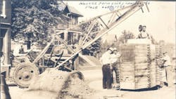
Before the mandate, Ameren Missouri performed inspections and data collection as necessary, using field crews equipped with digital cameras on manual, handwritten documents. The physical effort of accurately photographing underground conditions presented a huge challenge, requiring harnesses and multiperson crews to perform inspections safely. And, since the data that had been captured could not be merged into a central database, crews were unable to query that information or easily acquire documented manhole conditions. This made it increasingly difficult for the utility to maintain accurate documentation or prioritize repair and replacement decisions based on existing underground infrastructure data.
GIS Mapping Software Delivery
Starting in 2009, Woolpert embarked on the task of documenting the 8,000 structures that fell within Ameren Missouri's jurisdiction. Ameren Missouri's network was divided into 160 sections based on geographic regions, helping to organize the data-gathering process into manageable delivery areas. At each individual manhole inspection, the general condition of each cistern structure was documented: the material used in its construction and its exact location.
Locating the manholes using existing paper maps as a basis was often the first hurdle for the inspection team. Over the past 100 years, some of the original manhole locations had been paved over by new streets, new structures or parking lots. The manholes that could not be identified were classified with a status of cannot locate (CNL).
Condition documentation started with using a robotic camera to capture interior digital photography of each manhole and underground structure. The use of the robotic camera eliminated the inherent dangers of entering the enclosed space of a manhole with electrified equipment. During each inspection, crews documented the condition of the cistern ceiling, walls and electric components. Specific attention was paid to cable duct penetrations, cable supports and any other noteworthy characteristics. After completing individual inspections, data was compiled and delivered for immediate use.
Woolpert leveraged its GIS experience by using Gilware, the firm's proprietary ArcGIS-compatible (ESRI) software, which was originally created for field data collection on sewer systems. Designed for scalable customization, Gilware enabled capture of the manhole project's unique data requirements and then populated a centralized database with detailed field documentation. The software then integrated the database into a GIS-enabled ArcMAP with the precise location of each structure.
With the data and ArcMAP in place, reports of the inspection areas could be generated quickly and the structures were rated according to repair priority or severity of condition. This allowed Ameren Missouri to determine which structures needed immediate repair and which ones were showing signs of structural degradation. Essentially, every structure became a point on the map that tied to the database, providing a complete picture of site conditions, from the most recent digital photography to the structure's original construction sketches. Now in the fourth year of project execution, more than 7,800 inspections have been conducted.
Revolutionizing Day-to-Day Operations
The introduction of the data-collection process was revolutionary for Ameren Missouri in that it not only vastly improved visibility to its structural conditions but also provided a sustainable method for asset management and documentation. The immediate value of the inspection was to accurately compile a mapping database and identify which traffic-related manholes and network vaults were still in service, and determine which locations had been paved over and could not be located.
Just as important, an efficient inspection and documentation process helped to fulfill the PSC mandate. The map and database deliverables enabled Ameren Missouri to produce the necessary time-stamped reports of conditions required by the PSC guidelines. In addition, it allowed the utility to submit an annual report detailing the number of inspections completed, the number of repairs identified and the number of repairs completed that were identified in the previous year.
Ameren Missouri's new manhole housekeeping process also revolutionized day-to-day operations. Because every piece of information captured is now easily accessible in a centralized database, employees throughout the utility are requesting access to query this data for information about specific manhole conditions (for example, materials of construction and requiring water pump). The ease of getting information out of the new system has resulted in many employees discovering the value of routinely using this data. With the documentation process in place, every condition update (whether a replacement or repair) is accurately integrated into the database in real time.
The value of having an updated map and centralized database is especially evident during emergency situations, when information about structural conditions is literally at Ameren Missouri employees' fingertips for quick review prior to dispatching repair crews. For routine questions about a manhole, access to digital pictures alone has provided sufficient information to not require crews to conduct on-site visits.
Dan Bax ([email protected]) has served as a project manager/engineer at Ameren for four-and-a-half years. He holds a degree from the University of Missouri - Rolla and an MBA degree from Webster University. Bax is a registered Engineer-in-Training with the state of Missouri and also has his project management professional certificate.
Steve Boergerhoff ([email protected]) has served as a project manager at Woolpert for 10 years and has a total of 17 years of experience as a licensed professional surveyor in four states (Missouri, Illinois, Wisconsin and Iowa). He holds a BS degree in civil engineering technology from Southern Illinois University - Carbondale.
SIDEBAR: GIS-Enabled Field Data Collection
Working in enclosed manhole structures demands extra care and preparation for field crews. And, when there are 8,000 structures to inspect in a four-year period that require thorough documentation, expediency also is a requirement.
To accomplish this task, field data collection was approached with a combination of geographic information system (GIS) mapping technology to improve accuracy and remotely operated robotic, industrial cameras to reduce the danger of the inspection process.
Crews collected field data using Panasonic Toughbook field computers (pen tablets) and GPS units to pinpoint their exact location. Each pen tablet was equipped with software to record the physical and observable attributes of each manhole at the precise GPS location. All data was then integrated into a database and an ArcGIS format shape file to allow attributes of each inspection to be associated with the specific location.
Crews set up remotely operated robotic digital cameras over each manhole, reducing the risk, time and cost required for manual photographic inspection. The digital photography was integral to the documentation process and was available for review as needed. With this process in place, any repairs and inspections performed in the future will be updated in the existing database, allowing for accurate data collection and improved structural maintenance.
|
Companies Mentioned: Ameren Missouri | www.ameren.com ESRI | www.esri.com Missouri Public Service Commission | psc.mo.gov Panasonic | www.panasonic.com Woolpert www.woolpert.com |