Operations Beyond Visual Line of Sight
In July 2016, a team of industry experts stood next to a 345-kV line in Missouri, U.S., ready to conduct tests for beyond visual line of sight (BVLOS) flights with an unmanned aerial system (UAS). The objective was to test an aerial light detection and ranging (LiDAR) payload and then analyze the data for use in vegetation management of the line.
Increasing penetration of UAS in consumer and industry markets has raised the question of how electric utilities can benefit from autonomous flight. LiDAR-enabled UAS have the potential to facilitate utility vegetation management through the perpetual refresh of dimensional information. This refresh not only enables regulatory compliance, but also may facilitate a paradigm shift in utility vegetation management operations toward quantitative and data-driven programs that will drive safety and reliability benefits. Clear opportunities also exist to generate operational efficiencies through effective contractor procurement and auditing, accurate work orders, digital workflows and others.
Based in Missouri, Empire District Electric Co. has a perpetual and statutory need to maintain vegetation clearances on its transmission and distribution assets. Historical approaches for examining electrical clearances between conductors and vegetation have relied on visual ground and aerial patrols, which have most recently included LiDAR.
The use of LiDAR on manned platforms addresses several issues with visual patrols by achieving repeatable dimensional measurements, a comprehensive scan of all possible threats and determination of conductor sag. However, the cost of manned LiDAR has typically been a barrier to application, particularly for smaller projects where a mobilization charge for aircraft positioning may be incurred. For this reason,
Empire decided to explore whether a UAS equipped with LiDAR would deliver a comprehensive analysis at a better cost of application.
Technical Development and Convergence
Through collaboration with NM Group (Network Mapping Inc.) — a specialist provider of geospatial data, analytics, engineering services and software to electrical utilities — and its close work associate, Phoenix Air Unmanned, Empire was able to complete a test successfully from July 18-20, 2016, on 22 miles (35 km) of a 345-kV line in southwest Missouri.
The ability to capture LiDAR data from a UAS has emerged following rapid technological advancement and convergence:
· UAS technology has developed to a point where a precisely planned autonomous flight can be flown using parameters suitable for collecting LiDAR data, with aircraft far more reliable than those traditionally observed.
· Onboard LiDAR systems have decreased in size and weight while increasing in capability — driven by applications in autonomous vehicle navigation and other related areas.
· GPS, inertial systems and data storage systems have miniaturized, which has enabled survey-grade navigation, a prerequisite for using LiDAR effectively. These have combined to enable the deployment of small payloads on UAS in a range of new application areas, including utility asset mapping.

Daisy-Chaining of Visual Observers
The survey flights were piloted by Phoenix Air Unmanned, with NM Group contributing the flight plan, ground survey, post-survey deliverables and utility systems integration. The airspace coordination, flight oversight and approvals were provided by the Northern Plains UAS test site, one of six test sites designated by the U.S. Federal Aviation Administration to conduct research for industry partners. The aircraft was able to fly BVLOS of the pilot by stationing ground-based visual observers along the inspection corridor in a daisy-chain fashion.
A ground-based visual observer maintained visual contact of the aircraft and surrounding airspace while the aircraft transitioned through the observer’s designated area. The visual observer then handed off the responsibility of maintaining visual contact with the aircraft to another visual observer farther down the inspection corridor. Daisy-chaining of visual observers demonstrates the aircraft can fly BVLOS of the pilot while still monitoring the airspace continually for additional air traffic. The approval for daisy-chain operations is unique and, by partnering with the Northern Plains UAS test site, this capability was demonstrated during the successful research missions.
Platform and Sensor
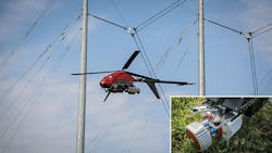
A myriad of unmanned aerial vehicles is available, but relatively few are suitable for industrial applications. The key decision criteria consisted of payload-to-weight ratio, endurance, robustness and autonomous control. Following a period of evaluation, a UAS based on the design of a conventional helicopter — the Pulse Aerospace Vapor 55 — was chosen. A conventional-style helicopter has larger propellers than multicopters, providing increased lift capacity and thereby an optimal payload-to-weight ratio. The design enables a high level of flight efficiency, achieving up to an hour of flight.
Prior to a mission, the pilot will carefully input flight parameters in line with the LiDAR flight plan. The pilot then commands the UAS to follow the flight plan, only intervening should an issue arise. This autonomous approach, as opposed to fly-by-eye piloting, ensures consistent data capture, thereby maximizing the quality of downstream processing and end-user deliverables.
When calibrated, planned and configured appropriately, the LiDAR system and platform combination produces data comparable to and in excess of the resolution from manned LiDAR flights, delivering close to 100 ppm2 at a flying height of 100 ft (30 m) above ground level. This ensures suitable depiction of the primary transmission circuit together with underbuild and any undercrossing wires. The presence of independent control enables the data to be confirmed at a high data accuracy of 4-inch (102-mm) root-mean-square error (RMSE) overall, with 2-inch (51-mm) RMSE for structures and conductors.


Data Analytics
The data collected in the system tests were reviewed and deemed suitable for transmission vegetation management, as-built modeling and new line design. Otto Lynch, vice president of Power Line Systems Inc. and the pioneer of using LiDAR in modeling to evaluate overhead transmission lines, was asked to review the data and derivative model in PLS-CADD.
Lynch commented, “The data quality observed from this UAV-based capture technique can produce an accurate as-built model equivalent to manned flights. This technology will not only benefit the maintenance requirements of already flown transmission lines, it will obviously open up even small transmission and distribution projects to the full benefits of LiDAR. BVLOS will be a game changer as federal and state agencies continue to increase pressure on facilities owners to better know the actual as-built state of their lower-voltage systems, including the wire movement clearance envelopes and structural capacities.”


A Milestone
Once considered an object of science fiction, the age of the autonomous utility is ready to be embraced. Empire’s project has demonstrated the capabilities of advanced UAS platforms and remote-sensing equipment to operate BVLOS of the pilot, a milestone for the transmission and distribution industry. It also has demonstrated the validity of associated analytics to deliver benefit for vegetation management and engineering operations.
However, while UAV data capture and analytics is a viable and available technology, it remains one of several options in the surveyor’s toolbox to be deployed on a project. The electric utility industry can anticipate the cost of application will continue to improve, enabling utilities to more regularly refresh data capture on electrical systems to feed analytics.
Jason Grossman graduated from Oklahoma State University in 2005 with a degree in agricultural science and natural resource management. He majored in environmental science and natural resource management with an emphasis on natural resource management. He started working in utility forestry in 2006 as a contractor with Environmental Consultants Inc. Grossman joined Empire District Electric in 2008 as the distribution coordinator, later advancing to vegetation control coordinator for transmission in 2013. He is a founding member of the City of Joplin Tree Board, for which he served as chairman from 2009-2013.
Nick Ferguson is senior vice president business development at NM Group (Network Mapping Inc). With a bachelor’s degree and MBA degree, he has an academic background and interest in the application of innovative spatial technologies to generate value for businesses. He has worked for several years alongside electrical transmission and distribution utilities with global exposure to best practices in the U.S., Canada, Australia, the U.K., the Middle East, Africa and India.