Duke's Transmission Vegetation Management Transformation
Utility maintenance strategies typically fall into one of three different categories: interval or time-based maintenance, condition-based maintenance or predictive maintenance. Transmission vegetation management (TVM) programs traditionally have relied on interval/time-based maintenance approaches along with specification documents to plan and execute vegetation management work.
In 2017, Duke Energy Corp. began a business transformation to address the ever-increasing challenges of safely and effectively managing vegetation along its transmission corridors. This journey included a shift toward a more data-driven operational strategy, as well as organizational realignment, adoption of innovative technologies, and development of new processes and procedures.
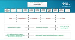
This transformation provided the opportunity for the utility to transition from an interval-based maintenance approach to a condition-based strategy, with predictive elements to drive reliability and program effectiveness. To help ensure the transition would be sustainable, Duke Energy implemented an enterprise-wide remote-sensing program (RSP) and developed the Work Planning, Analysis and Scheduling System (WorkPASS) to manage and execute the work.
These innovative programs and applications have enabled Duke Energy to migrate away from manual processes and tools, such as spreadsheets, to more advanced processes that leverage technology.
Part one of this two-part article series focuses on the utility’s development of a remote-sensing program.
Reasons For Change
The Duke Energy TVM organization is responsible for managing vegetation across six states (North Carolina, South Carolina, Florida, Indiana, Ohio and Kentucky). The organization includes four geographic operating regions (Carolinas East, Carolinas West, Florida and Midwest) responsible for managing transmission vegetation work execution. In addition to the four regions, the organization also includes a group responsible for providing enterprise TVM strategy, technology solutions, and common processes and procedures. The TVM team plans and manages vegetation work on more than 31,000 miles (49,890 km) of transmission lines, comprising approximately 6% of the total North American Electric Reliability Corporation (NERC) FAC-003 applicable circuit miles in the U.S.
Duke Energy has a well-established and industry recognized TVM program, which has maintained a disciplined and consistent approach to managing vegetation along the utility’s transmission rights-of-way (ROW). Until recently, TVM’s approach to managing vegetation along transmission lines has relied on interval-based maintenance with specifications that describe what work needs to be performed.
An interval-based maintenance approach has served the industry well for decades, but the regulatory and public environment has evolved rapidly. While resource constraints were typically the primary challenge for TVM programs in the past, the industry has seen utility commissions, regulators, legislators and property owners become more engaged, resulting in increasing expectations for the program.
As these challenges and expectations evolved, TVM determined that continuing to perform work as it has in the past (that is, managing the program manually through spreadsheets and performing maintenance using an interval and specification-based approach) was no longer a sustainable approach. Duke Energy needed to transform the way it planned and executed work.
The TVM team embarked on a transformation to establish a sustainable path for the future. The TVM business transformation initiative included changes to operational strategy, organizational realignment, technology solutions and program documentation. Key to the success of this journey was the implementation of data-driven technological solutions, along with analytical capabilities, to sustainably manage increasing expectations by performing the right work, at the right place, at the right time.
Business Transformation
While many actions were associated with TVM’s business transformation, two key actions proved critical to the sustainability of the initiative: strategic focus and organizational alignment. The team took a strategic focus using advanced data to identify and address potential vegetation threats and eliminate the previous reliance on a specification-based approach that could over- or under-prescribe the work required to address true threats.
Technology Initiatives
Two technology-related efforts were initiated to support the transformation: implementation of an enterprise RSP and WorkPASS. The RSP initiative was established to create a digital model of lines that can be analyzed to predict potential vegetation threats over the next six years to eight years.
Predicted threats from these analytics provide the data necessary to support a condition-based maintenance approach. The WorkPASS initiative was established to develop and provide the necessary tools and applications to effectively manage and execute a condition-based maintenance program focused on reliability and program effectiveness.
Cutting Down Risk
While some level of inherent technical risk is associated with technology implementations, Duke Energy TVM’s experience with previous remote-sensing and technology solution initiatives led to three issues being identified as potential risk factors:
- Sheer volume of data and the ability to manage it
- Solutions not being designed to fully meet use-case needs
- Limited capability to produce concise actionable deliverables for execution.
These risk factors were determined to be controllable when considered and addressed during the early stages of initiative planning. The following guidelines were used to mitigate the risk factors and provide general direction for the RSP and WorkPASS initiatives:
- Provide tree-canopy polygons
- Analyze threats under all rated electrical operating conditions
- Document reactive work threats
- Predict vegetation threats over a six-year to eight-year period
- Provide capability to manage and transfer large datasets
- Develop predictive reliability-risk analytics
- Provide scenario-planning capabilities for annual work planning
- Create optimized annual work plans
- Create an application that supports an end-to-end approach for the corridor (planned), floor and reactive management programs
- Support work unit and should-cost predictions
- Support multiyear work planning
- Provide actionable deliverables for execution (that is, predicted work units per stem at the tree-canopy polygon level)
- Support field mobile access
- Support assignment of work for execution
- Provide completed-work reporting capability
- Meet business-case objectives.
Establishing the RSP
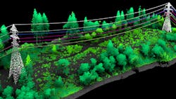
After identifying the guidelines, Duke Energy began developing the RSP program with an evaluation of remote-sensing options, which included satellite imagery, photogrammetric detection and ranging (PhoDAR), and light detection and ranging (LiDAR). The results determined LiDAR was the best option to meet the accuracy and resolution requirements of the TVM use case and supported the use of PLS-CADD engineering models to identify vegetation threats under all rated electrical operating conditions. In addition, the LiDAR option also supported additional use-case needs associated with transmission line engineering and asset protection.
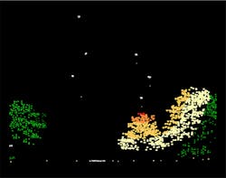
The methodology used to manage the threats was the next key decision point for Duke Energy’s RSP initiative. Across the industry, different approaches have been used for each unique program, some of which were tree inventories. Based on the size of Duke Energy’s program, as well as limits with remote-sensing technology, a tree inventory did not completely align with the utility’s strategic direction, and a volumetric approach (threat polygons) did not meet work assignment needs. Based on the evaluation, Duke Energy selected tree-canopy polygons, which were attributed with highest threat as the basis for managing threats.
Foundational Data
The RSP deliverables provide the foundational data needed to support a condition-based management approach. By requiring the threats from vegetation to be predicted over a six-year to eight-year period, the RSP deliverables support multiyear work planning and enable Duke Energy to understand and prioritize work on a condition (which indirectly accounts for time) and threat-type basis. Further, this approach is foundational for the utility’s risk analysis.
Editor’s note: The remote-sensing program is one of two major developments Duke Energy pursued as part of its vegetation management transformation journey. Learn more about the development of a work execution system, WorkPASS, in the next issue of T&D World.
Timothy J. (Jack) Gardner ([email protected]) is Duke Energy’s manager for Transmission Vegetation Strategy and Support. His team is responsible for providing enterprise TVM strategy, business transformation, technology, and support. In addition to leading the strategy and support functions, he also led TVM Business Transformation initiatives and managed the development and implementation of planning, analytics, and scheduling applications for TVM. He holds a B.S. in civil engineering from Virginia Tech and has been with Duke Energy for 22 years, after 20 years at AEP. During his career, he has led and managed TVM Strategy and Support, TVM Regions, Transmission Line Construction and Maintenance, ROW Acquisition, Asset Protection, Aerial Patrol Programs, Regulatory Strategic Planning, Asset Management, Transmission GIS, Transmission Line Mechanic Training, Remote Sensing Programs with more than 110,000 circuit miles acquired, numerous enterprise technology and process improvement initiatives, and construction engineering and project management on several hundred miles of 69-765 kV transmission line and fiberoptic projects.
About the Author
Jack Gardner
Timothy J. (Jack) Gardner is Duke Energy’s manager for Transmission Vegetation Strategy and Support. His team is responsible for providing enterprise TVM strategy, business transformation, technology, and support. In addition to leading the strategy and support functions, he also led TVM Business Transformation initiatives and managed the development and implementation of planning, analytics, and scheduling applications for TVM. Gardner holds a Bachelor of Science in Civil Engineering from Virginia Tech and has been with Duke Energy for 22 years, after 20 years at AEP. During his career, he has led and managed TVM Strategy and Support, TVM Regions, Transmission Line Construction and Maintenance, ROW Acquisition, Asset Protection, Aerial Patrol Programs, Regulatory Strategic Planning, Asset Management, Transmission GIS, Transmission Line Mechanic Training, Remote Sensing Programs (Mapping/LiDAR) with more than 110,000 circuit miles acquired, numerous enterprise technology and process improvement initiatives, and construction engineering and project management on several hundred miles of 69-765 kV transmission line and fiberoptic projects.


